
Onomastic survey in Eurasia
The importance of onomastics for studying world history has not yet been adequately appreciated. Meanwhile, it provides a wealth of material that can be used to reconstruct prehistoric ethnogenetic processes and understand distinct peoples' intellectual and spiritual development. A good example in this regard is the work of L.A. Nakhanova (Kazakhstan), dedicated to the peculiarities of the thinking of the Turkic peoples through the analysis of the functionality of toponyms in the ancient Turkic period (NAKHANOVA L.A. 2014). Her analysis allowed us to conclude that "how ancient toponyms reflected the interaction between people and nature in ancient periods…, how the worldview of the ancient Turks influenced the functioning of toponyms… and what was the role of toponyms in the history of the ancient Turkic people (Ibid: 1060)".
Other Kazakh linguists provide a theoretical basis for onomastic research:
Proper names, precisely defining the main concepts of culture, acquire a cumulative function in its pure form. Proper names, through onyms, turn into linguistic signs and linguistic units, create an onomastic model, an image of the world. An onomastic model or image of the world reflects people's ideas about the world and the properties of cognition of the world, which also acquire anthropocentric properties (ATABAYEVA M.S., EROL TURASHBEK. 2017: 4)
Using onomastic material is especially fruitful in multidisciplinary studies within the framework of macrolinguistics. In particular, using the graphoanalytical method, I determined the places of settlements of the ancestors of some modern peoples at the time of the formation of their languages. For the resulting graphic model of the kinship of the Turkic languages, correspondence on the geographical map was found in the territory between the Lower Dnieper and the Don. The formation of individual languages in the Black Sea steppes contradicted the "kurgan theory" developed by Marija Gimbutas, according to which Indo-Europeans lived in this territory, and became the creators of the Corded Ware cultures (GIMBUTAS MARIA. 1963). Due to various arguments, this contradiction was resolved in favor of the Turks, and one argument was the discovery of Turkic toponymy in Central and Northern Europe. The only descendant of those Turks who survived to this day is the modern Chuvashes, and their language has preserved the features of the Turkic proto-language more than other Turkic languages. It is this language that is used to interpret Turkic place names.
The interpretation of place names is generally probabilistic, confidence can be given by the large number of names deciphered using one language. The deciphered prehistoric toponymy of Eurasia is presented on separate maps in the Google My Maps system. As of July 2023, the following were found:
Anglo-Saxon place names in Continental Europe, deciphered using Old English – 1399.
Ancient Turkic place names, deciphered using the Chuvash language – 1219.
Cimmerian place names in Europe and Asia Minor, deciphered using the Kurdish language – 618.
Using the Chuvash language is because it has preserved the features of the Proto-Turkic language more than other Turkic languages. While most Turkic people migrated in different directions to Central Europe and Scandinavia and subsequently assimilated among other peoples, those who stayed in Western Ukraine retained their ethnicity. In the first millennium BC, they settled over a wide area of Eastern and Central Europe and became known in history as the Scythians. Some of the Scythians were the ancestors of the modern Chuvashes, so the Turks who originally inhabited Western Ukraine will be called the Proto-Chuvashes.
The number of place names deciphered by the Finno-Ugric and North Caucasian languages ranges from several tens to two hundred. Thus, we can conclude that in prehistoric times the course of European history was determined by the ancient Turkic People, and at the turn of the eras, the Anglo-Saxons, the Proto-Chvashes, and the Cimmerians-Kurds played a leading role in Eastern Europe. The historical fate of these peoples has developed in different ways, this is food for thought.
For the first time, the topic of ancient toponymy in Ukraine of Germanic and Proto-Chuvash origin was raised in a small brochure published in the Ukrainian language twenty years ago [STETSYUK VALENTYN. 2002]. This publication remained practically without attention in the scientific world, and in the future I had to seriously develop this topic alone, expanding the territory of research and the languages involved in deciphering enigmatic place names. Quite a lot of material relating to the whole of Eurasia has been collected, and over time it will be systematized and presented to the attention of inquisitive researchers
It is difficult to overestimate the importance of place names for the restoration of historical events, not reflected in written sources or oral traditions. In this sense, toponymy is not only a linguistic but also a historical science that helps to uncover the secrets of peoples living on some territory and their economic and cultural activities. Taking into account the great stability and survivability of geographical names, their careful study and linguistic analysis can provide us with, particularly reliable information.
People and their languages can disappear from the face of the earth, but toponymic names as a kind of proper names, not otherwise designating anything other than the object behind which they are entrenched, are easily assimilated by other peoples and thus can persist for thousands of years. Common words of the language are often replaced by foreign borrowings, as a result of the actions of various associations, new words arise that supplant the old ones with time. Similar processes in the field of toponymic names are not observed (SEREBRENNIKOV B.A.1959: 37).
The opinion of the Russian linguist is confirmed by the famous British typologist Bernard Comrie in an article devoted to a multidisciplinary approach to the study of the problems of human prehistory:
It is known that when some people capture territories formerly inhabited by other nationalities, the names of the localities (toponyms) used by the original settlers are most often preserved by new settlers. A striking example of this throughout history is the fact that many of the place names in North America are of Indian origin, including the names of such large cities as Chicago and Ottawa, both of Algonquian origin (COMRIE B. 2000: 5).
However, to restore prehistoric processes, it is important to know the location of the ancestral homes of individual ethnic groups, since the formation of the language and culture of peoples takes place under the influence of natural conditions and other geographical factors that determine, among other things, also the linguistic substrate and contacts with neighboring ethnic groups that played a significant role in the whole complex of ethnogenetic processes. Having no other reliable data, scientists for a long time placed great hopes on the toponymy data of distinct territories, believing that the linguistic affiliation of the prevailing toponymy could give grounds to consider these territories as the ancestral home of the speakers of the corresponding language. It is also important to know the chronological framework of the appearance of place names, but they themselves don’t give the answers to this question and therein the difficulty of its use lies. The place-name study (toponymy), really, couldn’t have probative value and gradually doubts about its use in studies began to be expressed because "… toponymic etymology is almost always conditional since it is unproven in the vast majority of cases" (MATVEYEV A.K.,1965: 10)
In the case of the Slavs, even a paradoxical situation turned out, where, according to L. Nederle, "there is no area in Europe, in general, that could be considered a Slavic Urheimat, as no region exists where geographical terminology would purely Slavic" (NIDERLE LUBORЪ., 1956: 34).
Throughout Europe, there are a large number of names of settlements, rivers, mountains, and lakes, which cannot be explained using the languages of the local population and therefore can be recognized as "dark". A peculiarity of the search for the interpretation of toponymy is that often in a certain area some names are accidentally consonant with the words of a language whose speakers now live far from these places, but whether they once lived here or not remains unknown. Therefore, to decipher the enigmatic place names, one must have a clear idea of which peoples lived in the territory under study and when. In many cases, historical information helps to find the truth, but some of the place names can come from prehistoric times and researchers make a mistake, restoring the events of bygone times only based on a guessing interpretation of incomprehensible names and often in favor of their people. Many modern ethnogenetic theories arose back in those days when comparative historical linguistics as a science was only taking its first steps, but erroneous ideas are firmly entrenched in the scientific world, and sometimes even the most dubious of them are used to create new far-fetched theories. In this case, the incomprehensible toponymy is adjusted to fit the previously drawn false picture. As an example, we can cite the seemingly solid work of the Kyiv linguist Prof. K. Tishchenko, which is based on the theory of O.N. Trubachev about the Slavic ancestral home in the Danube region (TYSHCHENKO KOSTYANTYN. 2006). In addition, the professor, in his confused work, adheres to rather original views, according to which the early Slavs had "pre-Indo-European contacts" (ibid., 51). Such a statement is reminiscent of the thought of one of the characters Yaroslav Hasek, who claimed that there is another one inside the globe, and moreover, the larger one. Kostyantin Tyshchenko knows a lot of languages. If you have such a mass of information in your head, you can extract facts from it for any theory. This is a typical approach of many linguists to scientific work. However, knowledge does not guarantee success in science.
And this work of the Kyiv linguist, and others like it, do not deserve attention, since they represent an arbitrary manipulation of temporal and spatial facts. However, in the second half of the 20th century, internal trends in the development of social sciences led to the use of precise, mathematical methods in them. This was also facilitated by the development of technology, which provided a powerful means of the mathematization of science – electronic computers. Gradually, starting from the simplest processing of statistical data, special mathematical methods were worked out in various branches of the social sciences, and a systematic approach to the study of social, historical, and linguistic processes even led to the development of special sciences that synthesize traditional and new mathematical methods of research. An example of such a science can be mathematical linguistics, a very broad science that uses mathematical methods of various kinds. In the short descriptions of the surveys proposed here, the deciphering of toponyms was based primarily on data on the original places of settlement of peoples obtained by the graphic-analytical method (STESYUK VALENTYN 1998., STESYUK VALENTYN. 2000) and paths of their further migrations restored by other methods. The essence of the method is to build a graphical model (scheme) of the relationship of languages of one language family or group based on lexical and statistical data. For the obtained model, a place is found on a geographical map with areas formed by natural boundaries (rivers, mountain ranges, etc.), which in ancient times limited contact between the population of these areas and contributed to the formation of separate dialects based on a common language. However, there can be no complete confidence in the correct placement of the circuit. We need additional facts that can be provided by archeology, toponymy, and linguistic substratum. If these facts do not contradict each other, then we can talk about the high reliability of the results obtained using the graphic-analytical method, and archeology allows us to determine the time frame for the stay of different ethnic groups in certain territories. Thus, the existence of such ethno-producing areas is a kind of empirical generalization, which, in the words of Vernadsky, "does not differ from a scientifically established fact"(VERNADSKY V.I. 2004, § 15).
On the formed clusters of areas, several dozens of primary ethnic groups were formed, the vast majority of which, either under the influence of various natural and historical circumstances, developed into modern nations, or, despite these circumstances, have retained their ethnic identity to this day. However, in the overwhelming majority of cases, peoples did not stay near their ancestral home, but for various reasons migrated to their places of present residence.
In identifying substrate toponymy in general, the so-called areal-retrogressive method of A.P. Dulzon was used i.e. discarding later stranger language layers on the substrate basis (POPOVA V.N. 2000: 50). This is trivial. Each name that attracted attention was checked for the possibility of etymologization using dictionaries of languages close to the language of the population that inhabited the study area in prehistoric times, and in the absence of such, etymological and bilingual dictionaries of modern languages were used. Deciphering toponyms has its own characteristics
The application of standard etymological methods to the toponymy does not yield reliable results because toponyms do not possess semantics which could be investigated in a similar manner to the rest of the vocabulary. As toponyms tend to lose their connection with the lexemes they are derived from, it is typical for toponyms not to follow exactly the same phonological developments as the rest of the vocabulary (SAARIKIVI JANNE. 2006: 291).
Their search has been promoted by the Google Map search engine, which suggests the location of similar place names in different parts of the world. Such assistance initiated the expansion of the area of toponymic surveys to the territory of Asia. The indicated Asian doublets of the Anglo-Saxon toponyms in Europe stretched out in the form of a chain, which displayed a certain regularity in their location. Searches for other Anglo-Saxon toponyms in this chain gave new additional material. In total, 125 Anlosaxon toponyms were discovered from the Urals to Sakhalin. Without a hint of technology, I would never have had the idea to look for Anglo-Saxon toponyms in Asia.
The reliability of deciphers of place names can be evaluated not only by a good phonetic similarity, but by the possible correspondence of the local topography, historical evidence, and the very location of toponyms. In the process of searching, their methodology was improved, and some regularities were also identified. If place names formed dense clusters or legible chains that reflect migration routes, then this already indicated that random coincidences interspersed in them did not distort the overall picture. The searches made it possible to decipher about four thousand dark toponyms in Europe and more than a hundred in Asia. Every year this number increases and any professional linguist could replenish the lists of deciphered place names. However, the author has no followers. This can only testify to one thing – the results of the work done are not perceived by official science. Of course, all unusual ideas are first of all rejected, and very rarely anyone seeks confirmation for them. In this case, it is surprising that no one even tried to independently decipher toponyms well known to him, which do not have convincing etymologies. Several toponyms, located in close proximity, may indicate their special accumulation. If you conduct a dragging search here, you can find additional cases. For example, I gave my interpretations of two toponyms in Portugal in the neighborhood of Lisbon, but I did not give an explanation for its name for several years. During this time, anyone could try to do this by looking in the dictionary of the Old English language to see how beautiful the name of this city is, but no one came up with such an idea, not even the one who deals with this issue.
And this happens at a time when earthlings are already going to colonize space, without even having a sufficient understanding of the history of the Earth. Meanwhile, space travel is impossible without complex mathematical calculations, and it is much easier to calculate the probability of randomness of all five thousand decryptions. However, the state of modern humanities is such that their development is carried out mainly according to the principle of "believe it or not." The deciphering of place names provides rich material for researchers, for example, they testify that some of them must have been preserved for several millennia and therefore it is possible that those place names that cannot be deciphered at all represent a Paleo-Europeian substrate. Separating them from the general mass can be one of the ways to restore the Paleo-European languages. This is the way we can restore the history of the Earth.
The ethnic identity of the peoples during the relocation was kept if it took place in droves with the preservation of family and tribal structure. Distinct families were moved by their own transport, together with their belongings, household appliances, and livestock. Such a convoy, accompanied by armed guards, stretching for several kilometers was unable to do a great day's march. Talking about the Celts and Scythians in the chapter CAIUS MARIUS, Pluiarch pointed out that "they did not swarm out of their country all at once, or on a sudden, but advancing by force of arms, in the summer season, every year, in the course of time they crossed the whole continent". (PLUTARCH, 1987, 516). Obviously, in summer, stops of various lengths are made in convenient places to study the possibilities of settlement. They were also being used for grazing livestock, replenishing water and food supplies, repairing carts, etc. Very often, at such stops, some group of migrants remains forever. These can be people who are tired of camp life, tired physically and mentally, sick, wounded and relatives who remain with them. As a result, a chain of settlements appears along the migration routes, the names of which are mostly adopted by newcomers, and thus they have been preserved to this day. This allows us to change our view of existing ideas about the predetermining factors for the emergence of permanent migration routes.
According to Radan Květ, the entire crust can be dismembered into numerous fractures – a geological phenomenon of fundamental importance. A dense network of fractures determines the configuration of the hydrological network as the main characteristic of the prevailing landscape types on the planet. The hydrological network is associated with a network of prehistoric footpaths that arose along the streams in antiquity due to the fact that after settlement a person with his involuntary efforts laid footpaths most often on the fluvial terrace nearest to the water flow. Among other things, the trails served as a means of transmitting information between distant human groups:
In the history of mankind, the original network of trails became the first information network. It did not have the main purpose of trade and military treks: all sorts of technological experience, as, of course, cultural, led to the union of thoughts, ideas, philosophical and religious beliefs, just as artistic tastes. (KVĚT R., 1998: 43).
Radan Kvet did not deny the existence of other possibilities for passing the terrain in later times, for example, "along the upper route." The prerequisites for the emergence of hiking trails were, first of all, physiographic, but sociogeographical aspects also arose. These latter determined the migration routes not connected with water flows, but, having arisen once, they continued to exist for many centuries and even millennia, improving as new technical capabilities developed. So, for example, along the modern Russian highway going from Moscow towards the Baltics, a clear chain of Estonian place names stretches, although the road goes through rough terrain without reference to any water flow. The same can be said about the E30 road, which runs through Poland from Brest through Warsaw to Poznan, along which a chain of Anglo-Saxon place names stretches.
The numerous toponymy in Central Europe was left by the Celts, who were the first Indo-Europeans to settle this territory. However, a significant number of alleged Celtic toponyms, despite the efforts of many researchers, did not receive a reliable interpretation, as evidenced by disagreements in views and scientific disputes over many decades (cf. MEES B. 2001). This is due to ignorance about the first inhabitants of Europe, which gave names to numerous settlements that still exist. These were not only Paleo-Europeans, whose languages are unknown to us, but also Turkic tribes who were the carriers of the Corded Ware Cultures (CWC).
It was they who left many of the oldest toponyms in Europe, which we managed to decipher. In total, more than a thousand Bulgar place names have been found in continental Europe. Various variants of the CWC were common in Europe from the Volga to the Rhine and from Southern Scandinavia to the Carpathians (see the section "Ethnicity of the Neolithic and Chalcolithic cultures of Eastern Europe ". It is on this wide territory that all Bulgarish toponymy is distributed. Most of the Bulgars assimilated among the later population, but those Bulgars who inhabited Western Ukraine retained their ethnicity and in Scythian times again settled in a wide area of Eastern and Central Europe (see the cycle "The Scytho-Sarmatian Problems").
In this regard, all Bulgarish place names can be divided into two groups – the times of the CWC and the times of the Scythians. The place names of Scandinavia, Germany, Poland, Germany, Scandinavia, and the Baltics definitely belong to the first group. They also include two strips of toponyms, one of which stretches along the Dnieper to Northern Belarus, and the other along the Desna to the area of distribution of the Fatyanovo and Balano cultures in the Upper Volga region and adjacent areas. They correlate to a large extent with the CWC sites. The second group includes two strips of toponyms from Western Ukraine, one of which stretches towards the Dnieper, and the second – to the Black Sea and further to Romania, as well as the toponyms of Hungary and Left-Bank Ukraine (see the map below).
Overview Map of the Bulgarish Toponymy of Ancient Times
On the map, icons in the form of purple dots indicate settlements with names of Bulgar origin, which may correspond to the times of the Corded Ware or close to them. Burgundy – later, Scythian time. Sites of CWC are marked with blue icons.
The deciphering of individual Bulgarish place names can demonstrate its methods and logic in general. The most common Bulgarish [lace name on the territory of Russia, Ukraine, Belarus, and Poland are containing the root zhuk"beetle" (Zhukovo, Zhukovka, Zhukovskaya, etc.). Moreover, the name of the villages of Zhukovo in Russia is one of the most common (more than eighty) among all, which in itself is surprising. It is doubtful that the Slavic name of the beetle insect was so often used for the names of human settlements. In German-speaking and English-speaking countries, there are literally a few toponyms from the corresponding appellative (German Käfer and English beetle "beetle"). The impetus for unraveling was given by the names of the villages of Zhukotin in the Lviv and Ivano-Frankivsk regions of Ukraine and the ancient city in Volga Bulgaria. The second part of these names – tin is not a possessive suffix, but a wandering word with the meaning "village", "settlement", or "fence" (for more details see below). Chuv. çăka"linden" is good for the first part because the abundance of lindens in these villages is striking. This word exists in similar forms in many modern Turkic languages (ancient Turk. jöke "linden").
Among the enigmatic place names of Russia, one of the most common is also the name Akulovo (35 cases) and its variant Okulovo (20 cases) in the places of the "o"-speaking population. In addition, in Russia, there are five more villages of Akulino and several others with the same root in the name. In general, there are more than sixty settlements of this type, and mainly in the northern regions northwest of the Tula-Nizhny Novgorod line. Given the high prevalence of these names, consideration of their origin from the word akula"shark" is not serious. Chuv. aka "arable land, plowing" is well suited for decoding decorated with the affix -la, which forms adjectives with a similar meaning from the nominal stem, however, there is also a verb akala "to plow ". For the agricultural population of the Fatyanovo variant of the CWC, moving from the forest-steppe zone in search of free land, this name suits the new settlements very well.
The most convincing examples of place names are those that can be associated with geographical terrain features. For example, the town of Khyriv in Stary Sambir district of Lviv Region is located in an area rich in pine forests. Since the Chuvash xyr means "pine tree ", the origin of the name from this word is probable. When similar examples could be found enough, the presence of the ancestors of the Bulgars in Western Ukraine should not have doubt. Sometimes the connection of a name with the peculiarities of settlements is compelling. The village Havarechchyna not far from the town of Zolochiv in Lviv Region is known for black pottery, which is manufactured according to the old original technology of firing. The name of the village just points out to the folk craft spread here – Chuv kăvar "embers" and ěççyni "a worker" united in kǎvarěççyni would mean "a worker with hot coals", that is "a potter". A common surname Bakusevich in this village may also have Bulgarish origin since an old man's name Pakkuç was used by Chuvash.
The name of the rocky ridge Tovtry in western Ukraine could be etymologized by Chuvash tu "mountain" and tără "top". As the name of the mountain sounds tau in many other Turkic languages, the primary name of the ridge could be Tautără. The mountain range on the border of Slovakia and Poland Tatry had the same protoform too. Tovtry stretch from Zolochiv in the Lviv Region to northern Moldavia and appear as separate limestone ledges and ridges that protrude above the surrounding expressive, mostly fairly level terrain, ie explanation as "mountain peaks" fits very well.
Among the clusters of toponyms of Bulgarish origin are present those that directly indicate the Chuvash ethnicity of the inhabitants of some settlements:
Chaus, a village in Mezhev district of Dnepropetrovsk Region. Ukraine.
Chausove, a village in Pervomaysk district of Mykolayiv Region. Ukraine.
Chausove, a settlement in Zhukovskiy district of Kaluga Region. Russia.
Chausy, a village in Pogar district of Briansk Region. Russia.
Chausovo, a village in Novodugino district of Smolensk Region. Russia.
Chavusy, a town im Mogilev Region. Belarus.
All the given names contain a root that corresponds to Chuv. chăvash "Chuvash". Apparently, the ancient Bulgars stayed in the noted settlements before arriving Slavic population which called by them according to the self-names of the inhabitants.
Even more than the Bulgars, the Anglo-Saxons left their traces in the toponymy, whose ancestral home was localized in the ethno-producing area between the Sluch, Pripyat, and Teterev rivers (see section Germanic Tribes in Eastern Europe at the Bronze Age). Most of the Anglo-Saxons at one time migrated to the British Isles, but some of their groups chose other paths that help restore the toponymy of Eastern Europe. Among the predominant Slavic names there are those that look completely non-Slavic. Quite densely they are located on the territory of the Sosnitsa culture of the Bronze Age. Some of them are strikingly similar to English words: Berkovo, Boldino, Brest, Burgovo, Volfa, Grinevo, Linda, Narovlya, Rikhta, Saltov, Sinkovo, Strypa, Fastov, Firstvo, Fishovo. It was near them that the search for Anglo-Saxon place names began. A concise Anglo-Saxon dictionary (HALL JOHN R. CLARK. 1916) and an etymological dictionary of Old English (HOLTHAUSEN F. 1974) were used. As a result, approximately one thousand three hundred possible Anglo-Saxon place names were found on the territory of continental Europe, some of which, however, can be attributed to random coincidences. A complete list of the place names is submitted separately on the Google map (see below), but the most convincing cases will be given here.
Anglo-Saxon toponymy in Eastern Europe
On the map, the Anglo-Saxon ancestral home is marked in pink, and the borders of the Sosnica culture are marked in blue.
The most common toponym in Russia, in general, may be Markovo, which has been recorded 97 times. One might think that they all originated from the name of a person, but such a name was not so popular among the people that the corresponding anthropotoponyms would far outnumber others in number. For example, the anthropotoponym Matveevo was found only 20 times, and only 60 from the most common name Ivan. Of course, part of the place names came from the name Mark, but still small, the bulk can be compared with OE. mearc, mearca "border", "sign", "county", "marked space". Such meanings of words are well suited for the names of settlements and are phonetically impeccable (modern English mark "sign", border"). The widespread Bulgar toponyms in Eastern Europe Mayak and Mayaki, which can be associated with Chuv mayak "landmark sign". In Russia alone, there are about fifty toponyms Mayak, although some of them come from Rus. mayak "lighthouse". The origin of the Chuvash word is not considered in etymological dictionaries (YEGOROV V.G. 1964; FEDOTOV M.R. 1996 etc.), apparently, it was not borrowed from Russian in the indicated meaning. It is almost impossible to separate the place names Mayak of Bulgar and Russian origin; one can speak more confidently about those that are among the clusters of other Bulgar ones or as part of chains consisting of place names of the same origin. This additional criterion is always used if it appears. The same place names that are located in isolation are taken into consideration cautiously or completely ignored.
There is also a fairly large group of Anglo-Saxon toponyms, which at first glance also come from another little popular name Victor. In Poland, Ukraine, Russia, and Belarus there are more than six dozen toponyms Viktorov, Viktorovo, Viktorovka. Such a number is simply incredible, given the low prevalence of this name among the Slavs, although some names of settlements can still come from this name. However, most of them were left by the Anglo-Saxons. OE wīċ "dwelling, village" and Þūr/Þōr "thunder god".
In general, when analyzing enigmatic toponymy, quite often it is surprising a large number of similar names that supposedly contain a Slavic appellative, but their form, motivation, and especially an extremely large number, cast doubt on this. For example, more than fifty such suspicious place names are based on the root rak "crayfish" in the Slavic languages – (Rakovets, Rakovitsa and similar.) This could be the name of a river or stream in which crayfish are found, but the vast majority of such names refer to settlements and only a few of them are hydronyms. In this case, an attempt was made to decipher them using Old English, in which the words racu "bed, stream" and the already mentioned wīċ "dwelling, village" were found. The motivation for the name of the settlement on the river bank is understandable. Two dozen toponyms Lukovets and under were formed in a similar way. from OE loca "fence, enclose".
Place names that contain the final formant -tyn/-tin /-ten/-den belong to the same type. Their search began after Ihor Danylyuk, one of the readers of my site, drew my attention to the fact that in Ukraine there are several dozen names of settlements ending in -ting. At first glance, this formant could be an extension of the possessive suffix -in, however, type formants – nyn, -ryn, -byn etc. almost never found in Ukraine. In this regard, it was assumed that the word tyn, as a component of a complex name, has its own specific meaning.
The search for its proto-form was carried out in several languages, and it turned out that the most suitable for the place names is OE tūn "fence", "field", "courtyard", "house", "dwelling", "village", "city" (modern English town "city "). The word has matches in other Germanic and Celtic languages. From some Germanic language, the Slavs borrowed the word tyn "fence", which now has a narrower meaning, but earlier it was used to refer to various kinds of settlements, as evidenced by such names as Kozyatyn, Krivotyn, Pravutyn, Lyubotyn, having a clearly Slavic component. It can be assumed that the word tyn in the meaning of "village" was also common among the population of Ukraine of a different ethnicity since there are examples of this word merging with non-Germanic and non-Slavic words (Zhukotin and others).
Locality names with similar formants tyn/tin/ten/den are often found in Central Europe, although they may have not only Germanic, but also Celtic origin, based on Irish dun(um) and Gal. dinum. Below are given as an example of several toponyms of possible Anglo-Saxon origin scattered throughout Eastern and Central Europe, which contain the component -tyn/-tin/-ten/-den:
Avratin, Boratyn, Boryatyn, Boryatyno, Burtyn, Delyatyn, Dirdyn, Dresden, Khotin, Manyatyn, Mirotyn, Obertyn, Eutin, Rybotyn, Roggentin, Rukhotyn, Skovyatyn, Wettin.
Most of the Anglo-Saxon place names were found in Russia, and some of them are quite common:
Levkovo (25 cases) , Levkovka, Levkov a.o. – OE. lēf "weak", cofa "hut, cabin".
Churilovo (24) – there was not found any reliable interpretation of the toponym in Russian, allegedly originating out of the name Churilo, which itself has no explanation. The high prevalence of the place name suggests that it should be based on a commonly used word and such is proposed by OE. ceorl "a man, peasant, husband", which corresponds Eng. churl.
Shadrino (24) – some of the names may occur from the dial. shadra “smallpox”, but their prevalence raises doubts about this interpretation for the overwhelming majority of cases. Usually, names with a negative meaning are very rare. M. Vasmer does not consider the origin of this word, therefore it can be assumed that it originates from an OE sceard "maimed, chipped" taking into account the metathesis of consonants. Another meaning of this word is "plundered". Such a name could be given to the settlements of the local population ravaged by the Anglo-Saxons. You can also consider OE sceader from scead "shadow, protection".
Ryazanovo (22) – the name may be partially assigned to settlements by people from the Ryazan region, and the name Ryazan itself, which occurs 5 times in Russia, can be of Slavic origin, although there is no certainty about this. You can keep in mind the OE rāsian “to survey”, which could be used during the resettlement of people when they have to find a suitable place to stop.
Boldino (11) – OE bold "house, home" is good suitable by meaning and phonetically. So could be called the individual estates of landowners.
The highest density of Anglo-Saxon toponyms is observed on the territory of the former Vladimir-Suzdal principality (see Ancient Anglo-Saxon Place Names in Continental Europe). There are especially many alleged Anglo-Saxon settlements on the territory of Moscow and in the immediate vicinity. Their density is such that it makes sense to show their location on a separate map (see below).
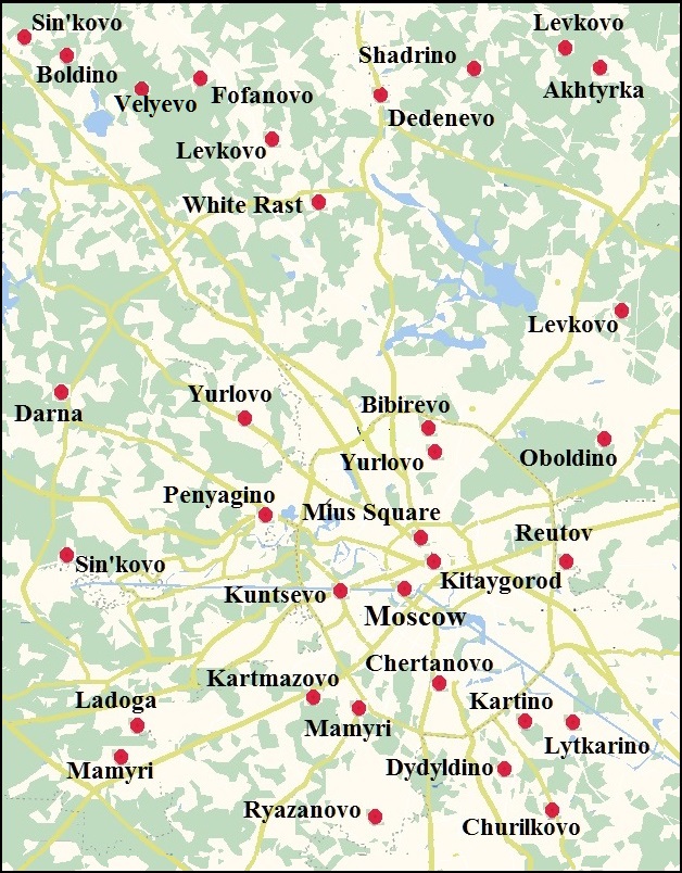
Some names have given decoding above, for others the following are proposed:
Chertanovo – OE. ceart "a wasteland, wild common land".
Kartmazovo – OE. ceart "a wasteland, wild common land", māga "son, descendant", or maga "powerful, well-off, capable".
Kitaygorod – д.-анг. ciete "hut, cabin".
Kuntsevo – OE cynca "cluster, bunch".
Lytkarino – OE. lyt "little", carr "stone, rock".
Mamyri – OE. mamor(a) "deep sleep".
Miusy, a historical district in Moscow – OE. mēos "swamp, bog".
Penyagino – OE. pæneg "coin, money".
Reutov – OE. reotan "cry, complain".
Place names can be connected directly with other data not always, and then the question of staying of an ethnic group on a certain territory is solved by comparison with reliable data on neighboring territories. For example, the Baltic place names in the Pripyat, Desna, and Seym basins indicate the inhabitation of this territory by the Balts at any time. V Toporov and the O. Trubachiov consider such names of the Vessia, Kovna, Luniya, Mazha, Morozha, Mytvitsa, Narovla, Nacha, Nertka, Osvitsa, Tremlia, Tsna, Shacha Rivers and many others as Baltic ones. Perhaps some of these names have Slavic origin, but in the mass, these names do not look Slavic. Other data about the presence of the Balts in these places are absent, but we know that the Urheimat of the Baltic was in another place and took a much smaller area. On the other hand, linguistic data about the contact of the Baltic with the Thracians could have taken place in the Danube basin. Thus, we can confidently say about the migration of the Balts to the Pripyat basin and its chronological framework. The boundary of the Baltic and Finno-Ugric place names quite clearly delineates the boundaries of settlements of the Finno-Ugric peoples in the west of their territory before the Slavic expansion:
As a whole, the northern and eastern boundaries of the Baltic tribes of the early Iron Age mainly coincide with the boundary separating the Baltic and Finno-Ugric toponymies and hydronyms. This boundary ran from the Gulf of Riga to the upper reaches of the Western Dvina and the Volga rivers. Turning further to the south, it is cut off Riverlands of the Moscow River from the basin of the Volga River and the upper reaches of the Oka River, then along the watershed of the Oka and the upper reaches of the Don came to the steppe (TRET'YAKOV P.N., 1982: 54-55)
Much information can be given by the study of Thracian or Illyrian hydronyms that are concentrated in certain small regions. On the contrary, analyzing the Turkic place names can give only scanty material to conclude. The Turkic languages are quite conservative, so in the first place, it is difficult to make the stratigraphy of the Turkic place names, knowing that Turks inhabited some areas in ancient and quite recent times. Secondly, the Turkic place names are spread over a large area, so localization of the primary places of Turkic settlements is difficult. Thirdly, Turkic people are numerous, so sometimes it is difficult to bind a certain Turkic name to a specific ethnic group. Approximately the same, but to a lesser extent, can be said about the Iranian place names. The analysis of the Slavic place names generally wound scientists to a standstill, as evidenced by the above words L. Niderle. We can get a lot of information from a comparative analysis of the place names of any modern Slavic territory and the location of the ancestral homeland of those people. However, such comparisons are not always possible or very difficult. For example, the comparison of the place names of present-day Poland and the former Polish Urheimat has no sense, since the Polish influences reached far into the territory of Belarus still in fairly recent times. The same applies to the Ukrainian, Belarusian, and Russian place names. The results may give a comparative study of place names of the Slavic peoples, the ancestral home of which lie far from their present-day territories. This applies to the Czech and Slovak place names and place names of the South Slavs.
Often, people have moved to new lands giving the same name to geographical objects, that they are accustomed to in the old places. This is manifested particularly clearly when comparing modern Czech and Slovak names of settlements with place names on the Urheimat of the Czechs and Slovaks. Much to a lesser extent, this phenomenon refers to the names of rivers. Only the names of the Morava rivers in Bohemia and the Moravia River in Volyn, and the names of the Uzh rivers on the ancestral homeland of the Slovaks and the eastern border of their present territory can be cited.
However, despite the efforts made, no convincing parallels were found between Slavic toponymy in the Balkans and in the historical ancestral homeland of the southern Slavs in the basins of the left tributaries of the Dnieper River. Contrary to expectations, in an article with a promising title, only one hydronymic parallel of Ukraine and Yugoslavia was given in its various versions – Pinya, Pinch, Penya, Pina, Pena, etc. (ZHELEZNYAK I.M. 1976: 39-49). In one of his works, J. Zaimov examines the etymology of about 9,000 units of Balkan toponymy but does not provide parallels for them from the territories of southern Slavic settlements in their ancestral homeland (ZAIMOV JORDAN, 1967). Attempts to find something similar on the map of the Dnieper basin brought very scanty results. Several parallel place names of the same root were found, they all had a different form of creation, so we can assume that these are just random coincidences: Babynino – Babino, Banichi – Banichan, Zhigayevo – Zhigantsy, Zhiglyantsy, Kokorevka – Kokorensky dol, Kokortsi, Kursk – Kuryani, Lyubazh – Lyubanci, Meshchovsk – Meshchan, Rzhanitsa – Rzhanichany, Rzhanik, Rzhenitsa, Selechnya – Selchani, Selce, Star – Staren. The roots of most of these toponyms are quite common, thus similar names could arise in different places of Slavic settlements independently of one another.
Investigating the names of large (longer than 100 km) and middle (50–100 km long) Balkan rivers, Georgiev concluded that out of the 27 large 16 or 19 have names of Thracian origin, 2 or 6 are Slavic. Among 58 middle rivers, 33 have Slavic names, 13 – Turkish, and 9 – Thracian (GEORGIAN VLADIMIR, 1960: 65). As if these results confirm the widespread view that the names of big rivers are changed by newcomers rarely, while small rivers receive new names often. However, the study of hydronyms in Eastern Europe has shown no definite pattern in preserving the names of large and small rivers. There are small rivers whose names go back thousands of years (for example, the Tarapunka River, rt of the Lyutenka, lt of the Pslo, lt of the Dnieper) and there are big rivers whose names have changed many times (Dnieper, Don, Dniester).
The practical absence of toponymic matches between the Balkans and the ancestral home of the Southern Slavs suggests they cannot be found enough in any territories inhabited by the same Slavic people but at different times. In this case, the significance of the existence matches in the place names of the Czechia and Volyn, Slovakia and the interfluve of the Slucha and Teterev rivers, however, an explanation should be sought for the absence of such a phenomenon among the southern Slavs. There may be several reasons. The first – the migration of the Slavs to the Balkans continued for several generations. This is a long period therefore children could forget the names of the ancestral settlements and the rivers closest to them. The second is that in the new lands, the Slavs settled in the already existing settlements. Third, in the old ancestral homeland, they either did not have permanent settlements, or these settlements had no names. The latter reason is at first glance absurd in the light of the existence of earlier Germanic toponymy. The second reason can be discarded because there are a lot of Slavic names in the Balkans and some of them undoubtedly originate from the times of the first settlers, as if they have no analogs in the Dnieper region. Knowing the large distance from the ancestral homeland of the Southern Slavs to the Balkans, we can confidently say that their relocation there lasted several generations. During this resettlement, the Slavs could have been left for a long time in Transnistria, Carpathians, but eventually, they ended up in the Balkans. On the contrary, the resettlement of the Czechs and Slovaks should have been short-lived – at least for the life of one generation. The same can be said about the relocation of the Poles. It is even possible that their invasion beyond the Vistula led to the relocation of the Goths to the Black Sea.
After becoming acquainted with the published works on the toponymy of Eastern Europe, the idea arises that hydronyms are an older and more stable layer in the total volume of toponymy but the oeconyms belong to historical times. However, it turned out that this was not the case – at first glance, unpromising studies presented us with big surprises. The traces of their stay on their ancestral lands were left by Germanic tribes namely in the oeconyms. In addition, the oeconyms provide an opportunity to trace the migration routes of tribes of different ethnicities.
The toponymy confirms the localization of the The second Turkic Urheimat in Eastern Europe and the stay of the Proto-Bulgars in the Western Ukraine, and their correlation with the Scythians. In general, a lot of the place names of Ukraine can be etymologized using the Chuvash language, however, the vast majority of them don't contain relation to natural and geographical features, which could be reflected in the proposed common names. In such circumstances, when random phonetic coincidence in the whole set of the alleged Scythian place names cannot be eliminated, statistics help substantively. The concentration of etymologized names using Chuvash in certain areas helps to determine the primary habitat of the ancient Scythians and ways to the later migration. Herewith, place names located in isolation may be regarded as random. To avoid, if possible, the influence of the subjective factor, their territorial affiliation remained unknown while etymologizing the whole list of "dark" place names of Ukraine. Already at the first attempt at their etymologization, it turned out that 334 place names could be interpreted using the Chuvash language (STETSYUK VALENTYN. 2002, 15). Then they were divided into regions and it turned out that most of them are located in the Lviv region, that is, 60. This is more than half of all toponyms of the Lviv region taken for analysis when more than half a quarter of them cannot be etymologized at all. The next places are Cherkasy region – 38, Vinnytsia – 32, Khmelnitsky – 32, Ternopil – 24, Poltava – 24, Zhytomyr – 17, Ivano-Frankivsk -15. Thus, the assumption about the location of the main habitat of the ancient Scythians south of Volyn was confirmed by statistical data. In the course of further study, additional place names of Bulgarish origin were repeatedly discovered by chance and mainly in the same areas, thus the given above numbers do not correspond to reality, although in general, it reflects the relative distribution of toponyms.
When analyzing the Turkis (Bulgarish) place names, it turned out that some of the names have matches not only throughout Ukraine but also in Germany, the Baltic States, and southern Scandinavia in the territory of the distribution of the Corded Ware culture, which creators were ancient Turks. There was no intention to make such searches since this culture existed five thousand years ago and there was not even a thought that the names of settlements could remain so long after repeated changes in a multilingual population. However, random finds led to targeted searches and they gave rich material. In general, in Continental Europe, more than one thousand place names of alleged Bulgarish origin have been identified.
Even though the distribution of place names between administrative units gives us a certain idea of their concentration, the presence of place names of different origin in the same region, sometimes in approximately near proportion, misleads us, as if the speakers of two or three different languages lived here simultaneously mixed. It is not so. When we plot place names of different origins on the map and ignore single toponyms in a cluster of a different origin, the boundaries between the clusters look quite clear and do not coincide with the boundaries of administrative districts.
Of all the place names of days of yore in continental Europe, Anglo-Saxon make up more than one quarter. Their search has been promoted by the Google Map search engine, which suggests the location of similar place names in different parts of the world. Such assistance initiated the expansion of the area of toponymic surveys to the territory of Asia. The indicated Asian doublets of the Anglo-Saxon toponyms in Europe stretched out in the form of a chain, which displayed a certain regularity in their location. Searches for other Anglo-Saxon toponyms in this chain gave new additional material. In total, 145 Anlo-Saxon place names were discovered from the Urals to Sakhalin. Without a hint of technology, I would never have had the idea to look for Anglo-Saxon toponyms in Asia. Therefore I take this opportunity to thank Google Inc. for promoting scientific progress.
However, toponymy not only helps determine the ethnicity of the creators of archaeological cultures and the routes of their migrations. A comprehensive analysis of clusters of toponyms attributed to any ethnic group opens up additional opportunities for reconstructing its history. And these opportunities are increasingly opening up for a researcher while working.
If we compare approaches to the study of toponyms throughout history, it becomes obvious that now the greatest interest is in identifying their motivation, because it is motivation that allows us to identify traces of culture and mentality (ALPATOV V.V. 2012:63).
The cited author supports the obvious idea of systematizing motives according to the formula “basis – attribute – predicate”, which forms the system core. According to the basis, it is understood that what is nominated, the attribute is the name that nominates the basis, and the predicate establishes the connection between the basis and the attribute (Ibid, 64). Such “science-similar” will simplify the explanation of motivation, which can be found purely speculatively without the help of any formulas. Practical work with specific material can help you find patterns in motivation that are more important than formulas and allows you to come to the following conclusion:
Semantic-motivational reconstruction in modern linguistics expands its tasks, which now include not only an explanation of the original meaning of the etymon but also the reconstruction of the entire nominative and cultural-pragmatic situation that contributed to the emergence of both individual words and entire lexical-semantic fields and their subsequent semantic development (BEREZOVICH E.L. 2012: 69).
Such conclusions will be more convincing when demonstrated by an example of work with large masses of place names, but such masses have yet to be discovered, which only emphasizes the need to work with those toponyms, the assumption of ethnic origin of which has serious justification and is not random in nature. This is the most important thing when working with place names.
The Full List of the Anglo-Saxon Place Names in Continental Europe
Iranian Place Names in Google Map
Bulgarish Place Names in Google Map
