
The Resettlement of the Indo-European, Türkic, and Finno-Ugric tribes in Eastern Europe.
The macrofamily of Nostratic languages usually includes Altai, Uralic, Dravidian, Indo-European, Kartvelian, Afrasian (obs. Semitic-Hamitic), but it may also include other language families. The use of the graphic-analytical method in research (STETSYUK V V. 1987) made it possible to abandon the idea of the genetic relationship of the Turkic languages with both Mongolic and Tungus-Manchu. In other words, their belonging to the Altai language family was recognized as erroneous (see The Far East. The Relationship of the Altaic and Türkic languages). The formation of separate proto-languages, recognized as Altai, took place in different places. The Altai ancestral home of the Turks seems to many to be a self-evident truth, but in fact, the Pra-Türkic language was formed in the Transcaucasia in the area around Lake Sevan in the vicinity of other Nostratic languages (STETSYUK VALENTYN. 1998: 27-31; see map below). On the contrary, the formation of the Mongolic and Tungus-Manchu languages took place in the Far East in the Amur basin simultaneously with the Korean and Japanese proto-languages. Many facts contradict the relationship of the Turkic and Mongolian languages, in particular, the lack of convincing correspondences between the words of the lexical core. This topic is considered in the article Checking the relationship of the Mongolian and Turkic languages by the lexicostatistical method (in Russian). For the sake of fairness, it must be said that at present the mainstream of European science is the acceptance of the thesis about "the absence of kinship between the Turks, Mongols, and Tungus", as I was informed by one of the Russian Turkologists in a private letter.
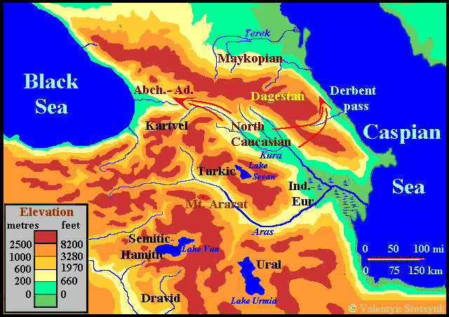
At right: Map of the areas of forming Nostratic languages.
Legend:
Dravid. – Dravidian, Ind-Eur. – Proto-Indo-European, Kartvel. – Kartvelian, S-H – Semitic-Hamitic, Turk. – Türks, Ural. – Uralic.
While the speakers of the Kartvelian language remained in their homeland, and the ancestors of the Semitic-Hamites and Dravidians moved south, the Indo-Europeans, Uralian, and Turkic peoples chose the northern direction. They left their ancestral home in the 6th millennium BC. and, moving an average of one kilometer a year, gradually reached Eastern Europe. The Indo-Europeans were the first to move, since it was they who occupied the extreme position on the territory of the primary settlement, and the Urals and Turks followed them.
According to archaeological data, in the V-IV centuries BC such late Mesolithic cultures were widespread on the territory of Ukraine: Kukrek, Murzak-Koba, Hrebenyky, Janislawice, Donets, and sites of the Studenok and Platovsky Stav types. Below is a map of the ethnocultural situation in Central-Eastern Europe, compiled by L.L. Zaliznyak, on the eve of the appearance of Nostratic tribes here and characterized as a Proto-Indo-European basis. In fact, Proto-Indo-Europeans has been created only Donets culture, and later they migrated under pressure by the Turks to the area of Janislawice culture. This area between the Volga and the Don Rivers was settled by tribes of Ural linguistic identity, which were followed after the Turks, and later divided into the Finno-Ugric and Samoyed peoples.
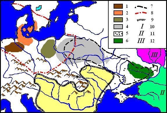
Ethno-cultural situation in Central and Eastern Europe in the V-IV mill. BC..
The orginal of the map (ZALIZNIAK L.L. 1995-5: 11. Fig. 5) was colored by the author.
Late Mesilithic: 1. Leinen (Leihen ?)- Warten (?) culture. 2. Oldeslohe (Svadborg? Maybe Svendborg). 3. Chojnice-Pieńki. 4. Janisławice. 5. Sites of finds of Janisławice edges. 6. Donets culture.
Neolithic: 7. Comb Ware culture. 8. Funnelbeaker culture. 9.
Balkan Neolithic. 10. Middle Eastern populations. 11. Proto-Kartvelians (wider – Caucasoids -V.S.). 12. Proto-Finno-Ugrians (Uralians).
Unfortunately, the author of the original map does not mention anywhere in the texts of his works about cultures outside Ukraine and at the same time gives them sometimes several different names. Further, we will build our arguments on the results of my own research.
New places of settlements of Indo-Europeans, Turks, and Finno-Ugrians were determined using the graphic-analytical method when suitable territories with clearly expressed ethno-producing areas were found for graphic models (diagrams) of the corresponding proto-languages (STETSYUK VALENTYN, 1998, 42-53). This topic is discussed in more detail separately for each of the proto-languages. Here, for a general overview of the settlement of the Nostratic peoples, below are presented maps with minimal explanations and the territories found of Indo-Europeans, Finno-Ugrians, and Turks in the East European Plain, on which the formation of distinct languages took place.
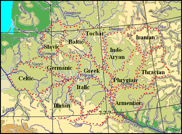
Map of the Areas of forming Indo-European languages.
Common space of Indo-Europeans was located between the Vistula River on the west and the Oka River on the east and south of the Daugava River. The Dnieper divided Indo-European languages into two groups – the Satem and Centum (more see in section "Migration of Indo-European Tribes in the Light of the Phonetic Features of their Languages".)
The map shows that the Greek language, which is in the center of the diagram, began to form in the area between the lower Pripyat, Dnieper, and Berezina rivers. To the west of it, beyond the Sluch (the left tributary of the Pripyat) between the Neman, Narev, and Yaselda rivers, the Proto-Germanic language was formed. Further to the Western Bug River or even to the Vistula was the area of the ancient Celts.
The Proto-Slavs dwelled north of the Germanic people on the right bank of the Neman River along the banks of the small rivers Merkis and Viliya. To the east from them to the Berezina River were the lands of the ancestors of the Balts. The Indo-Aryans inhabited the Sozh basin between the Dnieper and Iput, and further in the area between the upper Desna and the upper Oka rivers with the northern boundary along the Ugra River dwelled Irano-Aryans. In the first fragment of Vendidad (the first chapter of one of the parts of the Avesta), it is indicated that the Vakhvi-Datiya river flowed in the ancestral home of the Iranians. It has long been associated with the ancient Oxus River, but the analysis of archaeological material and written sources give grounds to identify Vakhvi-Daitya with the Amu Darya River (KHODZHAYEVA N.D. 2013: 114-120). On the other hand, rivers containing the Wahvi component "fertile, kind" in the name may be located in different parts of the territory inhabited by Iranian tribes at different times (STEBLIN-KAMENSKY I.M. 1999: 6.) In this case, with Wahvi-Daitya can be connected with the Oka River on the eastern border of the Iranian ancestral home that we have defined. The settlements of the ancestors of the Armenians were between the Dnieper, Desna, and Sula rivers, and the ancient Italics dwelled between Pripyat, Teterev, and Sluch rivers (the left tributary of the Pripyat).
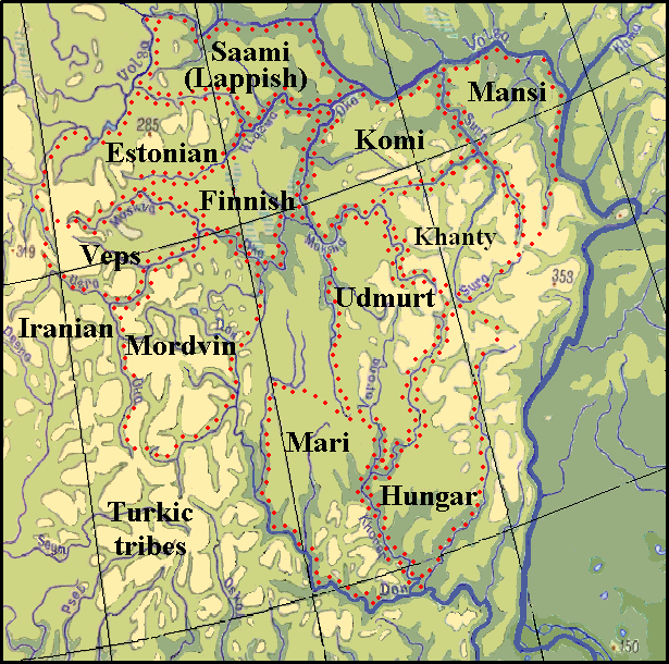
Map of Finno-Ugric settlements.
The whole Finno-Ugric territory is clearly limited by the Volga and Don River, playing the role of natural boundaries, as powerful water obstacles. Only Mordovians moved to the right bank of the Upper Don that is where it is easy to be crossed, came close to the Indo-European settlements separated from them by the Oka River. As the Indo-European space, the Finno-Ugric territory also has "empty" habitats. They are at least two – to the south of the Oka River and on the right bank of the Volga. You can assume that the Finno-Ugric tribe known as "Meshchera" populated the first "empty" area in the neighborhood with Finns, Mordvinians, and Cheremisses.
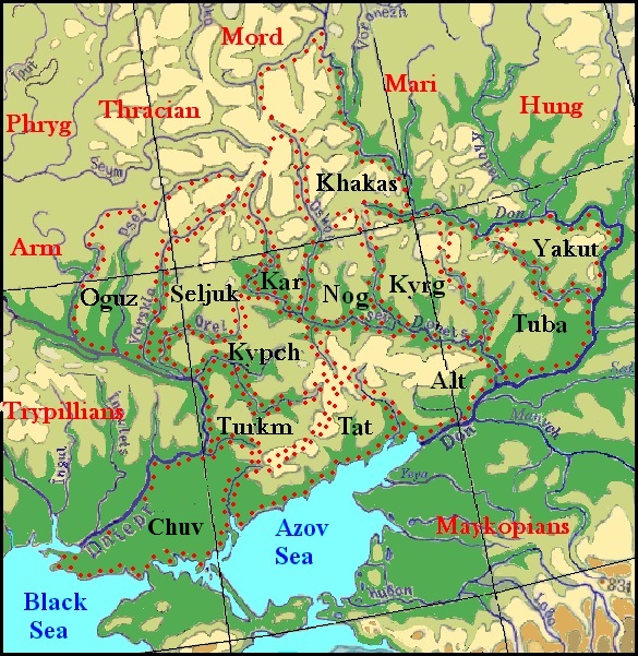
Map of Türkic setllements.
Due to the characteristic form of the graphical model of the Türkic languages, it was pretty easy to find a place for it on a map, but not there where it could be assumed according to prevailing actual views. It was impossible to find something suitable either on the Altai Mountains, where mountain ranges could be natural borders of habitats, or near an extensive network of the Ob and Yenisei Rivers. The diagram superimposed on the map only within the Dnieper-Don-Interfluvial area, where the characteristic bend of both rivers suggests how to arrange the resulting scheme (see the map). Such location was accepted considering that the Proto-Yakuts had to colonize the extreme eastern area, and Proto-Chuvashes – the extreme west of the common territory.
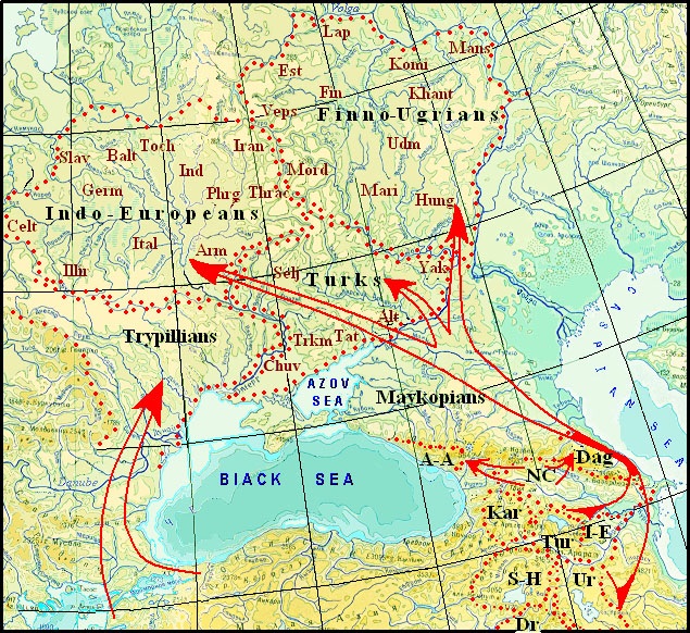
Left: The Resettlement of the Indo-European, Turkic, and Finno-Ugric tribes in Eastern Europe.
Legend: Nostratic peoples: A-A – Abkhazo-Adyge, Dag – Dagestanians, Dr – Dravidians, Kar – Kartvelians, I-E – Indo-Europeans, NC – the speakers of North Caucasian language, S/H – Semites-Hamits, Trk – Türks, Ur – Uralians.
Indo-European peoples: Arm – Armenians, Balt – Balts, Gr – Greeks, Germ – Germanic, Illyrians, Ind – Indo-Aryans, Ir – Iranians, Ital – Italics, Celt – Celtic, Slav – Slavs, Toch – Tocharians, Thrac – Thracians, Phrig Phrygians.
Finno-Ugric peoples: Est – Estonians, Fin -Finns, Hung -Hungarians, Khant – Khanty, Lap – Sami, Mans – Mansi, Mord – Mordvinians, Udm – Udmurts.
Turkic peoples: Alt – South Altaians, Chuv – Proto-Chuvashes, Yak – Yakuts, Khak – Khahasians, Tat – Tatars, Trkm -Turkmens.